In the rolling fields of northern China, beneath modern crops and shifting sands, an extraordinary chapter of infrastructure history has begun to reemerge. Archaeologists have uncovered a remarkably well-preserved stretch of what was once one of the world’s most ambitious road projects — a massive imperial highway constructed more than 2,200 years ago during the Qin dynasty, a road that rivals the scale and ambition of some of today’s major highways.
Far from being a simple dirt trail, this ancient route reveals a civilization capable of engineering, strategic planning, and logistical execution on a scale that demands a rethinking of early state power and mobility. In many ways, it challenges modern assumptions about when and how complex transport networks first emerged.
Table of Contents
A Road Lost and Found: The Qin Straight Road
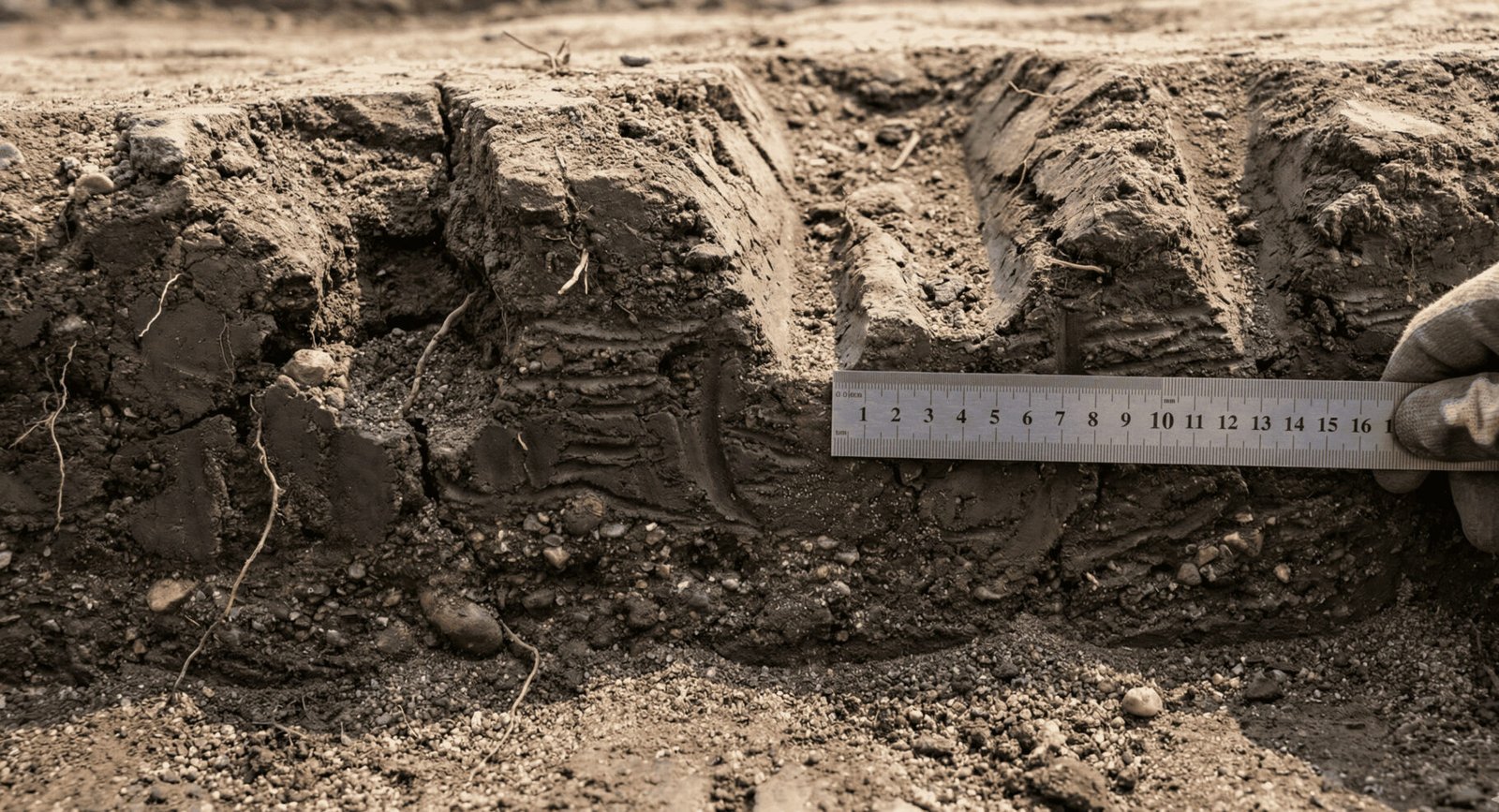
The newly uncovered section — about 13 kilometers (8 miles) long — sits in Shaanxi province in northwest China, a region rich in history as the cradle of the Qin dynasty. This dynasty, although short-lived, was historically transformative: it unified the warring states, standardized systems across the newly unified empire, and laid foundations for a centralized imperial state.
What makes this road extraordinary are its dimensions and construction. The surface averages roughly 40 meters in width — and in places widens to around 60 meters. By comparison, a modern four-lane surface highway typically ranges between 25–45 meters across, excluding shoulders and embankments. In many respects, this ancient road resembles the footprint of a modern multi-lane highway.
The original ancient highway, often referred to as the Qin Straight Road (or Qinzhidao), once stretched nearly 900 kilometers (about 560 miles) north from Xianyang — the Qin capital near today’s Xi’an — up toward what is now Baotou in Inner Mongolia. Its straight trajectory cut directly through challenging terrain, deserts, and hills in a remarkable demonstration of ancient planning and persistence.
Engineering in the Ancient World
For centuries, this route existed only in historical texts, such as the Records of the Grand Historian by Sima Qian, a foundational work of Chinese historiography. According to those accounts, construction began around 212 BCE under Qin Shi Huang, the first emperor of China, and continued for approximately five years — a colossal effort that mobilized hundreds of thousands of labourers.
The construction techniques were sophisticated. Instead of being a simple dirt path, the route featured:
- Compacted roadbeds created by layering and compressing earth to form a stable surface.
- Trenches and embankments, partially cut into hillsides or filled across low valleys, designed to keep the alignment as straight as possible.
- Reinforced slopes using rammed earth — a process that hardened the soil into a durable material similar in principle to modern foundations.
- Subtle drainage systems and fills to minimise water damage during seasonal rainfall.
These features indicate a high level of planning and execution, far beyond what typical nomadic or rural paths required.
Indeed, modern archaeologists liken this deliberate straightness and embankment work to methods still used in road building today — where engineers “fill valleys and level mountains” to maintain a direct line, prioritizing efficiency and speed of movement.
More Than Just a Path: A Strategic Lifeline
So why was this road built with such ambition?
For the Qin state, mobility was not a luxury — it was central to survival. The northern borderlands were constantly under pressure from nomadic groups like the Xiongnu, who lived north of the empire’s frontiers. Rapid movement of soldiers, supplies, and messages was essential for defence, and poor roads could mean the difference between victory and devastation.
Unlike defensive structures such as the Great Wall — which served primarily to block or slow invaders — this road was a strategic artery of movement. It enabled imperial armies to travel north quickly, retake lost ground, resupply distant garrisons, and maintain communication across the sprawling territory.
Nearby the newly uncovered road section, archaeologists also discovered an ancillary site believed to be a relay station or logistical hub. Items such as pottery fragments and tile evidence show activity at this station continued even into the succeeding Han dynasty, indicating the road’s use outlived its original builders and remained vital for decades.
Historians therefore see the Qin Straight Road not merely as a military corridor but as a comprehensive logistical network supporting governance, commerce, administration, and rapid response to crises.
 (1)")
Rediscovery Through Science and Technology
Despite its historical prominence, the precise route of this road faded from memory for centuries — buried under dunes, transformed by agriculture, or lost to the slow march of environmental change. Earlier archaeological efforts had uncovered fragments in the 1970s and again in the 2000s, but the extent and continuity remained elusive.
In recent years, advances in satellite remote sensing have revolutionised archaeological discovery. Researchers compared historical descriptions with modern satellite imagery to identify faint linear patterns hidden beneath the surface — features so subtle they are often invisible to ground-level observers. Once identified, these anomalies guided field surveys that confirmed the presence of embankments, compacted surfaces, and cuttings.
Through this blend of old texts and new technology, the imperial road — once theoretical — now sits exposed as a physical reality.
Ancient Road Meets Modern Comparison
When modern audiences hear about a road “wider than a highway,” it inevitably prompts comparison with today’s infrastructure. While the Qin road lacked asphalt, signage, and engineered concrete foundations, its footprint, construction strategy, and strategic purpose share fascinating parallels with today’s highways.
| Feature | Qin Imperial Road | Modern Highway |
| Typical Width | 40–60 meters | ~25–45 meters (four lanes) |
| Materials | Rammed earth, fills, cuttings | Asphalt/concrete, engineered base |
| Main Purpose | Military and state logistics | Civil transport and freight |
| Route Planning | Straight alignment prioritised | Balance of straightness, safety, environment |
By prioritizing straight paths — even through difficult terrain — early engineers anticipated modern planning strategies that value directness for speed of transport. Of course, modern highways add safety features, engineered drainage, environmental mitigation, and millions in materials science — but the basic logic of connecting strategic points remains.
 (1)")
Reframing Ancient Power and Connectivity
This discovery reshapes how historians view the Qin dynasty’s logistical capabilities. Far from being merely a ruthless regime known for autocratic legalism and grand projects like the Terracotta Army, the Qin state emerges as an organisation capable of complex infrastructure management, long-distance coordination, and sophisticated engineering.
Infrastructure like the Qin Straight Road helped central authority extend into distant regions, reinforcing control while enabling movement of people, goods, and ideas. Provincial officials could rely on predictable routes; military commanders could reposition troops quickly; and economic activity could flow along the same corridors that moved grain, mail, and edicts.
This road also illustrates how mobility shaped empire — not just through walls and armies, but through networks that disciplined space, linked regions, and supported long-term state coherence.
Lessons for the Present and Future
In a world increasingly obsessed with connectivity — whether through highways, railways, digital networks, or global corridors like China’s Belt and Road Initiative — the Qin imperial road resonates as a powerful historical antecedent. Ancient planners recognised that connectivity influences economic activity, defence postures, political cohesion, and cultural exchange.
By studying ancient transport networks, modern planners can ask questions about longevity, durability, and impact:
- Which routes remain meaningful centuries later?
- Which fall into disuse once political dynamics shift?
- How do infrastructure projects shape economic geography?
The Qin Straight Road, buried for two millennia, reminds us that ideas about connectivity and statecraft have deep roots — and that today’s road networks are part of a long continuum of thinking about how humans link places and people.
A Living Laboratory for Archaeological Research
The newly uncovered section promises ongoing study. Soil analysis may reveal more about construction techniques; wear patterns could illuminate usage intensity and travel speeds; and associated sites like relay stations may offer deeper insight into the daily rhythms of imperial transport.
Researchers also aim to understand how ordinary people related to this massive project. Did local villagers benefit from markets and security? Or did labour demands and state surveillance impose costs? These nuanced questions add depth to our understanding of ancient society beyond leadership narratives.
Conclusion: A Road Through Time
The rediscovery of the Qin Straight Road is more than another archaeological headline. It’s a testament to human ingenuity across time — a vivid reminder that many so-called modern innovations have ancient antecedents. As each new segment of this historic highway is uncovered and studied, we gain a richer picture of how early empires moved, connected, and controlled vast territories.
In doing so, this ancient road also offers a mirror: beneath our own highways, buried hopes and ambitions persist — waiting to be rediscovered, studied, and appreciated as milestones in humanity’s long journey toward connectivity and shared space.