A comprehensive, human-centered analysis of a groundbreaking climate study and what it means for billions of people downstream
From the soaring peaks of the Himalayas to the sprawling plains of South and Central Asia, the mountains of High Mountain Asia (HMA) are often called the “Water Tower of Asia.” They feed the rivers that sustain more than a billion people — fueling farms, cities, ecosystems, and economies.
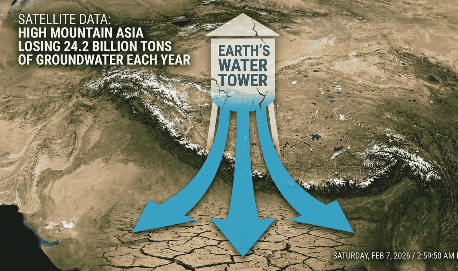
Now, cutting-edge satellite technology has uncovered a stark and urgent truth: this vital water reservoir is shrinking at an astonishing rate of about 24.2 billion tons per year.
This article dives deep into how scientists made this discovery, why it matters, what’s driving this rapid depletion, and what this could mean for the future of water security across Asia.
Table of Contents
How Satellites Uncovered a Hidden Crisis
Groundwater — the water beneath our feet — is one of the hardest natural resources to measure directly, especially in remote, mountainous regions. Traditional methods rely on sparse well measurements that provide only isolated snapshots. In areas like High Mountain Asia, where peaks, glaciers, and complex terrain dominate, these methods fall short.
That’s where satellites come in.
An international team led by researchers at the Chinese Academy of Sciences used sophisticated satellite observations combined with artificial intelligence (AI) to reconstruct two decades of changes in groundwater storage.
Here’s how they did it:
Multi-Source Satellite Integration
The researchers integrated data from multiple Earth-observing satellites — each providing unique glimpses into the Earth’s water cycle, gravity field, and land surface conditions. By blending these data sources, they created a more complete picture of how groundwater levels have shifted from 2003 through 2020.
AI + Earth System Modeling
To make sense of these massive datasets, the team developed an AI-powered model. This wasn’t just number crunching — it allowed scientists to reconstruct historical groundwater changes, identify patterns, and separate the influences of climate, glaciers, and human activity.
Validation with Ground Measurements
To ensure accuracy, the satellite-based findings were compared with thousands of groundwater well measurements and other independent datasets — strengthening confidence in the alarming trends being revealed.
What the Satellite Data Revealed
🔻 1. A Massive Loss of Groundwater Storage
The most striking finding: High Mountain Asia is losing around 24.2 billion tons of groundwater every year.
To put that in perspective:
- That’s more water than many large rivers discharge annually.
- It’s roughly equivalent to the annual water use of a country like India or Pakistan.
- This loss far exceeds the historical variability seen over decades.
2. Two-Thirds of the Region Is Declining
Approximately two-thirds of HMA exhibited declining groundwater storage between 2003 and 2020. Many of the steepest drops occurred in densely populated, irrigation-intensive basins such as:
- The Indus River Basin
- The Ganges–Brahmaputra Basin
- The Amu Darya Basin
These are regions where agriculture — and hence human survival and economic activity — depends heavily on underground water reserves.
3. Climate and Human Influence Both Matter
The researchers identified two main drivers of the decline:
- Climatic Factors: Changing precipitation patterns, glacier melt dynamics, and temperature shifts contribute nearly half of the observed groundwater variability.
- Human Water Withdrawal: In agricultural zones downstream, irrigation demand has steadily increased, especially after 2010, amplifying water loss.
It’s a combination many scientists had suspected — but now confirmed with unprecedented clarity from space.
4. Glaciers Offer Only Temporary Relief
For a brief period, melting glaciers can release water, slightly buffering groundwater loss in some high-elevation areas. However, this effect is temporary and unsustainable, likely to diminish sharply later this century as glaciers shrink.
Why This Matters for Billions
The consequences of this groundwater loss are enormous — not just environmental, but social, economic, and geopolitical.
Food and Agriculture at Risk
Many regions in South and Central Asia rely on groundwater for irrigation — especially in dry seasons. As aquifers decline:
- Crop yields may fall.
- Irrigation costs rise.
- Farmers face growing uncertainty.
This could intensify food insecurity in areas where millions already struggle with hunger.
Domestic and Urban Water Supplies Threatened
Cities and towns across the region depend on groundwater wells for drinking water:
- Smaller communities especially may run out of usable water.
- Urban water systems may struggle during droughts.
Water scarcity could drive greater rural-to-urban migration, increasing pressure on cities.
Economies Under Stress
Agriculture represents a significant portion of the economies in many countries of the region. Declining water resources can slow economic growth, increase rural poverty, and strain government budgets.
Conflict and Cooperation Pressures
Shared river basins and aquifers don’t respect national borders. Reduced water availability could:
- Heighten tension between countries sharing water resources.
- Increase competition for access to critical water supplies.
- Test regional cooperation mechanisms in South and Central Asia.
The Broader Climate Context
The loss of groundwater in High Mountain Asia doesn’t happen in isolation. It’s part of a larger suite of climate-driven changes unfolding across the globe — many of which satellites are essential to track.
Satellites: Our Global Environmental Sentinels
Modern satellite systems — many equipped with radar, gravity sensors, and hyperspectral imaging — have transformed our ability to observe Earth from space. These tools:
- Detect glacier melt and ice mass loss.
- Monitor sea level rise.
- Observe atmospheric greenhouse gas concentrations.
- Reveal shifts in groundwater storage.
They have become our early warning system for climate impacts.
A Growing Body of Satellite-Driven Science
Recent satellite-based climate findings include:
- Changes in greenhouse gas lifetimes in the atmosphere.
- Hidden drought patterns in mountain snowpacks.
- Underestimated tree cover losses across tropical landscapes.
These diverse observations reinforce one central theme: Earth’s water and climate systems are shifting rapidly in ways that were previously hidden beneath the surface — now visible from space.
What Can Be Done?
Declining groundwater in High Mountain Asia is a wake-up call. But it’s also a roadmap for action.
1. Smarter Water Management
- Improve irrigation efficiency.
- Invest in water-saving technologies.
- Adopt crop varieties that need less water.
2. Better Monitoring and Forecasting
Satellite data should be integrated with ground measurements and local knowledge to:
- Create real-time water tracking systems.
- Alert communities to emerging shortages.
- Inform policymakers about long-term trends.
3. Regional Cooperation
Shared resources require shared solutions — from joint monitoring programs to equitable water allocation frameworks.
4. Address the Root Causes
Ultimately, climate change and unsustainable water use are core drivers. Reducing emissions, transitioning to climate-resilient agriculture, and protecting natural ecosystems will help stabilize water cycles.
A Future Seen From Space
Satellites have shown us what was once invisible — the dramatic decline of the water that sustains millions of lives.
High Mountain Asia’s groundwater loss isn’t just a scientific statistic. It’s a human story of diminishing resources, rising risks, and an urgent call for coordinated action.
Our ability to see the change is a triumph of technology. Our ability to respond will define the future of a region — and potentially, the planet.